Amid India’s renewed push for homegrown digital innovation, Mappls, developed by MapmyIndia, is fast emerging as a strong challenger to Google Maps. The app has been designed to meet the unique challenges of Indian roads and is already a preferred navigation system for leading automotive brands across the country.
Founded by Rakesh and Rashmi Verma, MapmyIndia has been building digital maps of India since 1995. Its decades of data collection and local expertise now power Mappls — a product fine-tuned to understand Indian cities, highways, and every turn in between.
A Digital Address Revolution
One of Mappls’ most talked-about innovations is Mappls Pin, a six-character digital address system that integrates with the government’s DIGIPIN initiative. Each pin represents a precise geographic location, allowing users to find or share exact spots with ease. Unlike traditional addresses, this system supports hyperlocal navigation, offering directions down to the specific house or building.
Smarter Travel With Built-in Toll Calculators
The app includes a toll and fuel calculator, helping users estimate travel costs before they hit the road. By factoring in toll charges, fuel prices, and route distance, Mappls recommends the most cost-efficient path — a feature particularly useful for long-distance and frequent travelers.
3D Junction Views for Safer Navigation
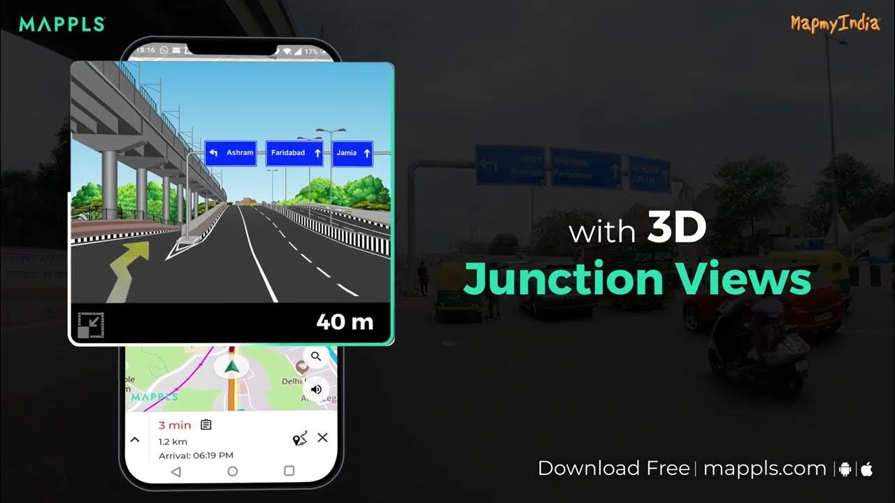
Another standout feature is Mappls’ 3D junction view, which gives a realistic visual of complex road intersections, flyovers, and exits. These photo-realistic representations reduce last-minute confusion and improve overall driving safety, making it ideal for busy urban traffic zones.
Real-Time Traffic Signal Timers
Mappls has partnered with Bengaluru Traffic Police to introduce live traffic signal countdowns at over 160 intersections. This AI-powered integration provides real-time signal data and even adjusts routes based on congestion. It’s one of the first such features in India, giving Mappls a unique edge in smart mobility solutions.
Alerts for India’s Real Road Conditions
Unlike global platforms, Mappls includes India-specific hazard alerts such as potholes, sharp turns, and speed breakers. The app also warns users about surveillance cameras and accident-prone zones, helping them drive smarter and safer on Indian roads.
Backed by Decades of Mapping Expertise

MapmyIndia’s long-standing presence gives Mappls an unparalleled database of India’s geography. The company’s partnership with ISRO, announced in 2021, allows it to integrate satellite data for more accurate, indigenous mapping coverage — a move that strengthens India’s digital independence.
Mappls isn’t just an alternative to Google Maps; it’s a platform that deeply understands Indian driving habits, terrain, and challenges. With its growing adoption among automotive manufacturers and everyday commuters, it’s steadily proving that India can build world-class navigation tech for its own roads.
Follow Tech Moves on Instagram and Facebook for more updates, product breakdowns, and insights from India’s growing tech innovation ecosystem.